Everything you need to know to prepare your hike in the Ardennes
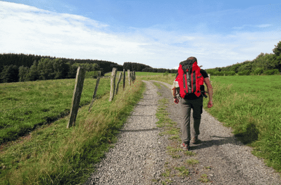
Preparing your luggage for a hiking trip
With Europ’Aventure, you have the possibility of hiking without having to carry your belongings on your back. We will take care of the transportation of your main luggage so that you can enjoy your experience during your day of walking.
Luggage transport is provided directly by the accommodation or by trusted local partners. They are safely deposited at your arrival accommodation.
In order to facilitate their transport, we insist on choosing a suitcase or bag that is easy to handle (only one main piece of luggage per person) and whose maximum weight should not exceed 15kg.
What to pack for your organized trip?
- Water-resistant walking shoes with a good sole profile. Take shoes with good ankle support to avoid sprains! And above all, get used to your hiking boots before starting the crossing of the Ardennes.
- Hiking socks that will prevent painful feet and blisters.
- A waterproof and windproof jacket
- Breathable clothing (light fabric). It is advisable to wear different layers instead of one thick garment to make it easier to adjust your clothing to the temperature throughout the day
- Sunglasses, cap and sunscreen in summer
- Walking sticks if necessary
- Your gourd
- A pocket knife for the picnic
- Toilet paper, tissues
- Plastic bag to put your waste in
- A compass or your phone (GPX tracks)
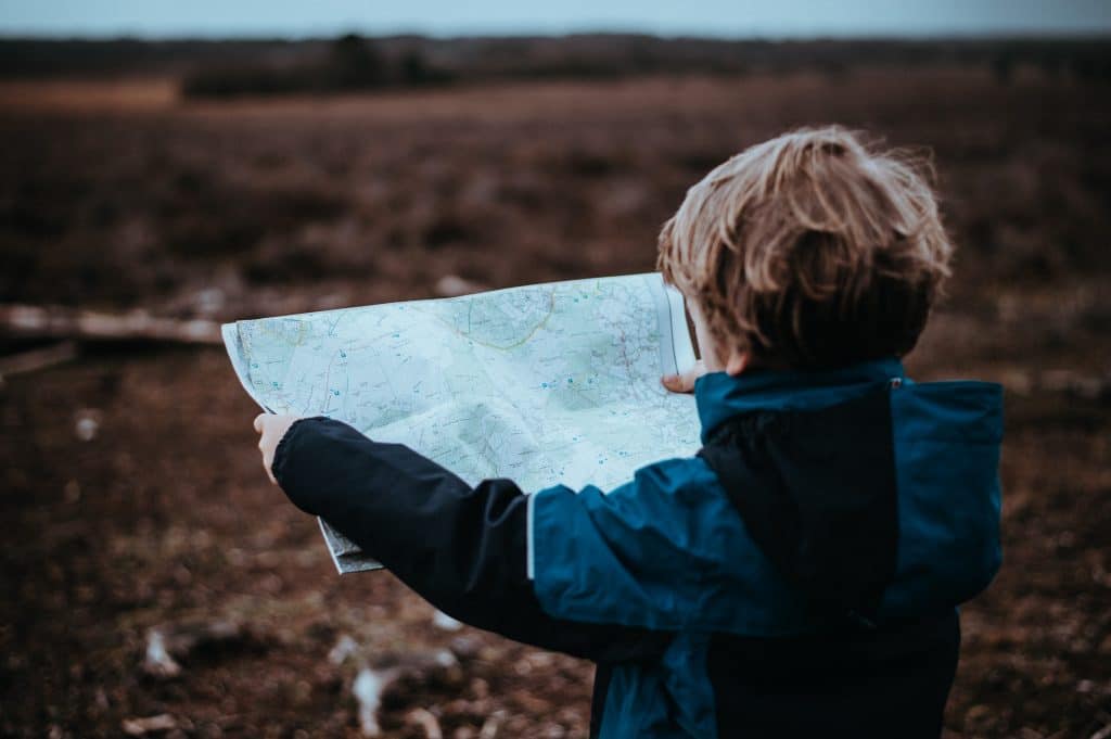
- A map
- A small first aid kit
- Your camera (or phone) to share your experience with us!
Europ’Aventure’s advice
For the days of walking, we advise you to take a good backpack (+/- 15 liters) in order to carry easily your water bottle, your picnic as well as the necessary things during the day (rainwear, sun cream, …). As the Belgian weather is very changeable, opt for a backpack that contains a rain cover to protect your belongings in case of rain.
Accommodation along our hiking trails
By choosing Europ’Aventure you have opted for a stay in the authentic Ardennes. All our accommodations have been quality partners for many years. On some evenings, you will stay in *** or **** hotels, some of which have a gourmet restaurant. Some even have a swimming pool or a wellness area. On other evenings, you will stay in 3 épis guest houses where the emphasis is on a personal welcome. In any case, you will live a unique and diversified experience.
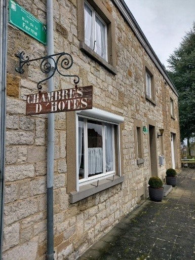
A la Pier’rare – Bed and Breakfast
On the paths of the Transfamenne, Marie-Louise welcomes you warmly in her typical Ardennes house which will plunge you into the atmosphere of the old days. Located in a very quiet rural area, Marie-Louise is still actively involved in her beautiful flower garden, vegetable garden and orchard. Don’t miss the opportunity to taste the delicious dishes made from local products and from the breeding farm located 200 m away.
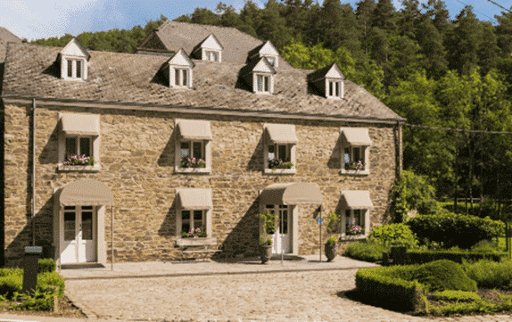
Le Moulin de Daverdisse – Hotel
Nestled in the heart of the Ardennes forest, the Moulin de Daverdisse welcomes a large number of our hikers on the Transardennaise (on foot, by bike or mountain bike) and the walk between Lesse and Semois. The Moulin de Daverdisse, which will soon celebrate its 100th anniversary, warmly welcomes you to their accommodation.
Behind its pretty facade, hides a comfortable and romantic interior, the bright and spacious rooms of the hotel offer all the comfort of a 4 star hotel. Let’s not forget the smile and the good mood of the owners of the accommodation who take care of the comfort of their client and an incredible stay.
Unless otherwise indicated, you will always be received on a half-board basis (breakfast and evening meal) in order to make the most of the hotels and your evenings to relax and unwind.
The climate in the Ardennes
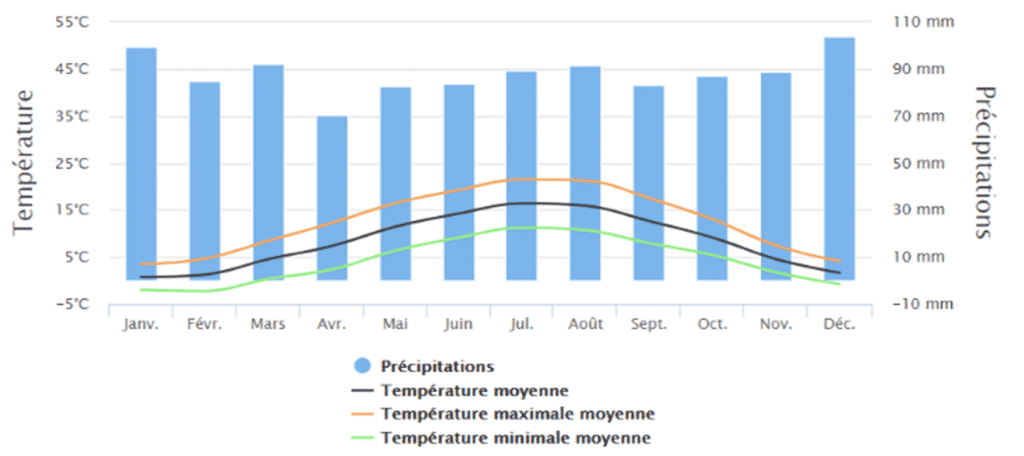
Europ’Aventure has been the specialist in hiking holidays in the Ardennes for over 35 years. We offer departures all year round without interruption. Therefore, it is important to understand the climate and its constraints before choosing your stay. Each season offers different advantages: mild temperatures in summer, splendid colours and the sound of the deer in autumn, the possibility of walking in the snow and solitude in winter, nature in full bloom in spring…
The Belgian Ardennes are actually a low mountain range. Compared to the rest of Belgium, the Ardennes are generally much wetter. Because of the many differences in altitude in the La Roche area, clouds sometimes linger between the hills and make some trails muddy. This region has relatively hot and humid summers, cold winters with frost and snow and rainy autumns.
However, there are marked differences between the north and south of the Ardennes. The Hautes-Fagnes, to the north, are located at a higher altitude and have abundant precipitation and frequent fog with an average annual temperature of 7°C. Further south, the Gaume region, which you cross on the Transgaumaise, has a much milder climate. The cicada can be found here and vines grow on the southern slopes of the region.
Europ’Aventure’s advice
As the weather can change quickly and thunderstorms can occur (especially in July), we advise you to always pack a rain jacket.
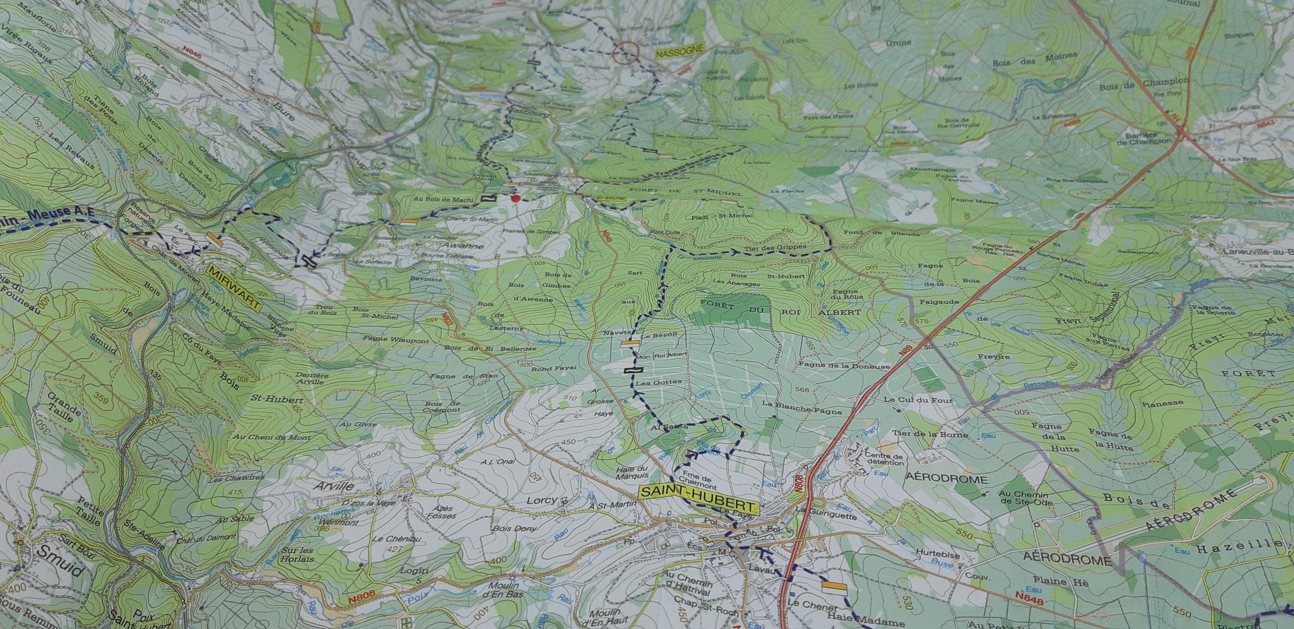
The marking and the paths of our walking routes
All Europ’Aventure’s trips are “free”, meaning that you are free to choose your departure date and that you walk without the constraints imposed by a guide or a group. You can enjoy the scenery at your own pace.
To facilitate your experience and navigation, all our routes are marked. That is, they can be followed without a map by simply following markers. The marking of most of our routes such as the Transardennaise, the Transgaumaise or the Transfamenne was realized by the Maison de la Randonnée – GTA Belgium also called “Maison de la Randonnée”. Denis, its founder and president, is the creator of these different itineraries. Europ’Aventure is the exclusive partner of the Maison de la randonnée – GTA Belgique for the sale of trips on these routes. For more information, visit https://www.gta.be/.
For some routes, we collaborate with other organizations such as the natural park of the two Ourthes for the EscapArdenne – Eisleck Trail or the Grande Forêt de Saint-Hubert for the Grand Tour between Lesse and Lomme.
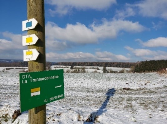
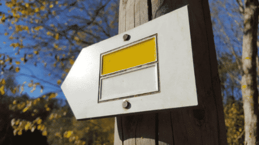
In most cases, the beacons are yellow and white. All of our walking tours are marked along the way, unlike the cycling and mountain biking routes. We have made GPX tracks of all our hikes, available for free on request.
The 3 types of markings on a hike
The yellow and white signs indicate the direction to follow. They can be found along paths on trees or poles.

The double yellow and white signs indicate that you must change direction. They are located a few meters before the intersections. This indication is always followed by a single stripe of yellow-white paint in the new direction you are to follow. For the GR markings (red & white), the upper sign will indicate the direct route (it will be longer to the left or to the right). For the GTA markings (yellow & white), these two signs are identical. The directional change is not specified.

The yellow-white cross indicates roads that you should not follow. This is an essential marker and you should never go beyond a cross.
The paths on our various routes are varied but always accessible and practicable. You will have the opportunity to walk on wide paths in the forest or in the middle of the fields, on small roads that cross villages, on winding paths following the course of rivers. The beacons can therefore be found in different places: on trees, on posts, … The beacons are sometimes found a few meters before the intersections.
If you don’t see any more tags, go back to the last place you saw them. Also use the map to find your way. Be careful, at the end of the stage, it is possible that it is necessary to leave the markings to reach the hotel.
Europ’Aventure’s advice
Despite the installation and the remarkable maintenance of the markings throughout the hikes, we still advise you to consult a map regularly.
The hiker’s code; respecting nature while hiking.
The Ardennes forest, with its thousand year old history, today covers the south of Belgium, the north of the Grand Duchy of Luxembourg and part of the French department of the Ardennes. It represents the most important forest cover in Belgium. In the province of Luxembourg, it simply covers 51% of the territory with its 313,000 ha. In the country’s most forested province, every second square metre is covered by a tree.
Europ’Aventure has been the hiking specialist in the Ardennes for over 35 years. We love and respect nature, especially the forest. We ask that people who travel with Europ’Aventure have the same respect for nature and do everything to preserve it.
Some tips to adopt throughout your stay

Respect the predetermined hiking trails. Walking off the trail degrades crops and upsets the balance between vegetation and animals. The signposting of our itineraries allows you to follow the appropriate tracks in order to fully enjoy the environment of our Ardennes while protecting it.

Do not scare wild or domestic animals. Also avoid disturbing them, feeding them, handling and crushing the smallest of them (ant hills, beetles, …).

Respect the calm and serenity of the forest. Avoid shouting that might scare away animals or disturb other hikers.

Do not leave any trace behind. In order to preserve nature, take your waste with you.

Do not light fires in the wilderness during your stay. The risk of fire is greater than you think!

It is not allowed to camp in the forest. There are bivouac areas for this purpose. The fine for non-compliance is € 125.00 per person.

Do not mutilate the trees, avoid picking and do not cut down a protected species. Learn to appreciate and recognize the fauna and flora in their natural environment.

Be courteous to other hikers, cyclists, locals, …
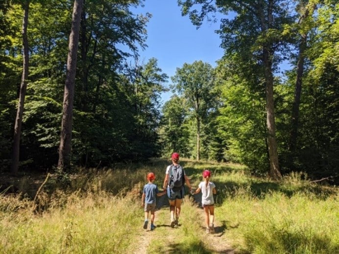
During the hunting season
The primary role of hunting is to regulate the density of wild boar, deer and roe deer populations. Indeed, the overpopulation of these animals was causing a significant degradation of the ecological biodiversity of the forest. According to the hunters, hunting, when properly practised, has a great ecological role.
Even if it is a highly controversial subject, hunting legislation in the Walloon Region is increasingly moving towards more ethical, ecological and respectful hunting practices for forest users.
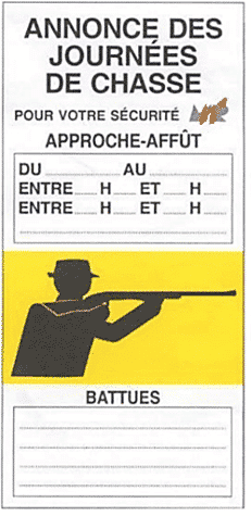
During the hunting season, from October 1st to December 31st, it is necessary to pay extra attention to one’s own safety by respecting the information or prohibition signs. Some of the stages of our hikes go through hunting grounds. To ensure the safety of walkers, prevention (yellow) and prohibition (red) signs are posted at the entrances to the hunting areas along the routes. It is therefore essential to follow the instructions on the posters.
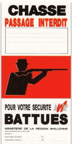
The yellow signs inform you of the different battues and the red signs forbid you to enter this sector of the forest. The two posters announce the dates and times of the hunts as well as the authorization number of the Walloon Region.
The tourist offices in the region (tourist offices, tourist information centres, etc.) and the associations specific to the forest hold the hunting calendars, so do not hesitate to contact them for more information. If your trip is affected, Europ’Aventure will also give you all the necessary information before your departure.
How to read an IGN map when hiking?
Learning to read will give you more autonomy and safety during your hikes. A map shows the elements of the terrain on a single horizontal plane, diagrammed and seen from above. Once you get used to it, you won’t be able to do without it!
Understanding the scale of a map
The most common scale for tourist maps is 1:25,000, which means that 1cm is worth 250m (so 4cm for 1km).
Orienting and understanding your map
North is always located at the top of the IGN map. By aligning the elements of the terrain with the different elements represented on it, you will find the correct orientation.
Concerning the inclination of the slopes, the closer the contour lines are, the steeper the slope.
The colour codes of the map
- Green represents wooded areas, vegetation
- Yellow/white represents crops, meadows
- Blue represents water points (rivers, lakes, …)
- Orange represents the contour lines
- Black represents infrastructures, buildings, … That is, anything that refers to human intervention.
To facilitate your experience and navigation, all our routes are marked. That is, they can be followed without a map by simply following markers. Most of our routes, such as the Transardennaise, the Transgaumaise or the Transfamenne , are marked by theASBL GTA, also known as the “Maison de la Randonnée”. However, in spite of the installation and the remarkable maintenance of the markings throughout the hikes, we still advise you to consult a map regularly.
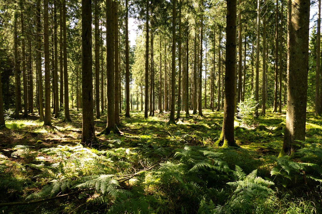
The forests and animals specific to the Ardennes
The forests
Crossed by the Transardennaise, the Central Ardennes is a vast plateau culminating at 589m in the Saint-Hubert forest. This landscape is characterised by a succession of valleys separated by wooded hills. Rich in rivers, the Lesse and the Lomme flow towards the north-west, the Ourthe towards the north and the Vierre, a tributary of the Semois, flows towards the south.
The forests of the Ardennes are mostly composed of deciduous trees such as beech, ash, oak, maple, birch, spruce, etc. They make up half of the surface of the province of Luxembourg and a quarter of the Ardennes. The thick layer of conifer needles on the ground prevents the development of other plant species in the undergrowth.
The animals
This flora covers an incredible fauna: wild boars, foxes, weasels, deer, otters, beavers, etc. These animals don’t come out at specific times and can therefore be difficult to see for some.
It is obvious that noise and bright colors scare these people. The best hiker walks calmly, alone or in a small group. Insects and birds are undoubtedly the easiest animals to spot on your hikes.
Most of the others run away when they see a human. Our forests are full of a multitude of animals typical of our regions. You may be lucky enough to meet a wild boar (with or without its young), a deer, a roe deer, a fox, … And take a look at a stream, they are full of fish (trout, grayling, …) !
The wild boar, the most popular animal in our regions, lives mostly at night and hides under leafy branches during the day. Fearful of humans, it may run away at your approach. Don’t panic, it never attacks humans!
As for the deer, it is also difficult to observe. It rests during the day and moves around shortly before nightfall. Harmless all year round, male deer should not be approached during the mating season, from September to October.
Observe the tracks on the ground all along the Transardennaise trails, one of these animals has surely passed just before you!