The Great Hiking Trails (GR©)
The long-distance footpaths (GR©) are walking routes marked out by the association of the same name. These trails form a network of more than 5,000 km throughout the Wallonia and Brussels regions.
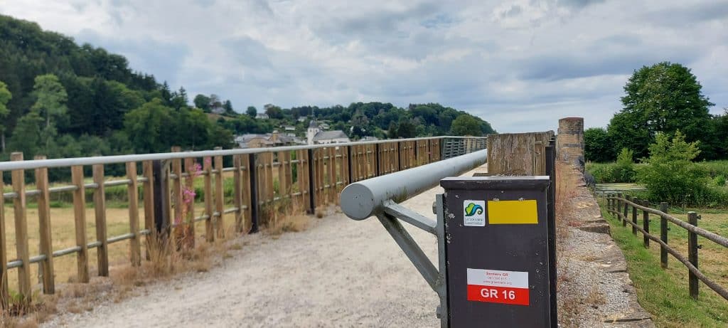
Each GR© route is recognizable by a number or a name (e.g. GR 16 “Sentier de la Semois”) and is integrated into the global network of these paths. The well-known red and white line allows you to follow these GR© itineraries over several days on a specific path or on different sections.
Each route is accompanied by a “topo-guide”, a paper guide with detailed explanations, maps and other necessary information.
The growth in the development of GR© trails has involved classifying them into four categories:
- ” Linear routes of major connections”.
- Themed itineraries
- Loop” hikes
- The “family loop” hikes
These different types of trails allow us to offer a wide choice of trails corresponding to the expectations of different publics, fond of hiking.
According to the statutes of the association, ” its social purpose is to make known, promote, encourage and facilitate pedestrian tourism” through the creation and marking of routes, protection of nature and landscape, publications, etc.
A little history…
The origin of the GR Trails in France.
It was in 1904 that the development of an interest in pedestrian tourism was observed with the creation of the “Touring Club de France”. The increase in the number of walking groups and the introduction of paid vacations in 1936 led to a craze for discovering nature on foot.
France is seeing many hiking trails develop on its territory and attract more walkers. The growth of interest in these paths led to the creation of the Comité National des Sentiers de Grande Randonnée (CNSGR) in 1947, followed by the inauguration of the first Sentier de Grandes Randonnées, the GR©3 between Orléans and Beaugency (France).
And in Belgium?
After the war, the development of various “Touring Club Belgium” projects enabled Belgium to see the creation and development of new hiking trails on its territory.
Unfortunately, a few years later, in the early 1950s, the TCB gradually lost interest in the trails and abandoned their maintenance. Following this, several walking groups joined forces to launch the “GR©” plan in Belgium under the name “CNBSGR, Comité National Belge des Sentiers de Grande Randonnée”.
This committee very quickly set up the first Belgian GR©, the GR©5, for which the first Topo-guide was printed in 1965. This GR©5 was born in 1963 thanks to three hikers from Liège, Lucien Cailloux, Henri Léonard and Alain Dawance, who wanted to extend the white and red markings of the French GR©5 to the Netherlands.
The beginnings of the CNBSGR are not easy due to the lack of contributions. In fact, the association lives solely on donations and subsidies provided by a small number of various groups (certain tourism federations, for example).
However, the association was able to overcome its financial weaknesses because only ten years later, the white and red network already extends over 900 kilometers and the international contacts increase year after year.
To divide up administrative tasks and decentralize marking responsibilities, the abbreviation C.N.B.S.G.R. was shortened to “S.G.R.” in 1979, and regional delegations were created.
One of the first managers of the Luxembourg regional delegation was Denis Jusseret, also founder of Europ’Aventure. Find out more about our travel agency in the ” About us ” section.
Today, the GR© network covers more than 8,500 km on the Belgian territory: more than 5,000 km in Wallonia and Brussels and 3,500 km in Flanders.
The markup
Marking of the Belgian GR© trails is carried out by teams of 440 volunteers, coordinated by regional managers.
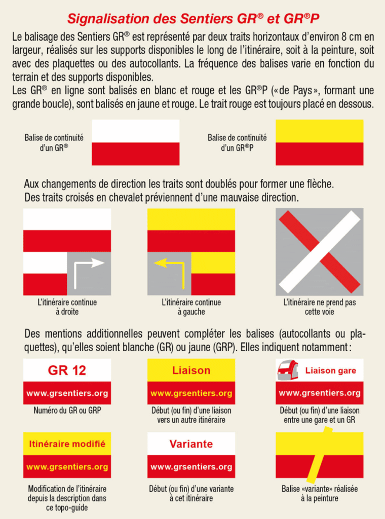
The white and red paint marks of the GR© are visible in different places: walls, trees, posts, etc. All along the routes, the markings are presented in different forms:
- A simple white – red line means the continuity of the route on the road you are walking on. You can continue to hike on the same trail.
- The double white and red signs indicate that you need to change direction. They are located a few meters before the intersections. This indication is always followed by a single stripe of white-red paint in the new direction you are to follow.
- The red-white cross indicates roads that you should not follow. This is an essential marker and you should never go beyond a cross.
- A simple white-red line superimposed by a white slanting line indicates the variant of a route.
There are also yellow and red markings that correspond to the GR de pays trails. The codes for this markup are similar to the white and red.
You can find all the information about the marking of the GR© paths on the official website of the ASBL.
Thanks to the irreproachable maintenance of the GR© markers, all routes can be completed using them alone. However, it is always advisable to have a guidebook which is a real complement to the hike. Some would even say that it is essential…
But what is a guidebook?
Each itinerary developed by the GR© has a topo-guide associated with it. This real reference tool highlights :
- An overview map (1:250.000) with the complete route
- IGN maps, i.e. topographic maps, more detailed (1:50,000) with the colored route of the GR© trail taken.
- Historical and touristic explanations on the itinerary as well as on the places crossed along the way.
- Various practical information such as accommodation, supermarkets, train stations, etc.
- Technical information about the trail such as walking time and mileage, elevation changes, map numbers, etc.
All these guides are available on the store of their website.
The organization of stays on these GR© trails
Since 2021, Europ’Aventure collaborates with the GR© association and offers itinerant stays on the GR© trails in Belgium. We propose today two itineraries:
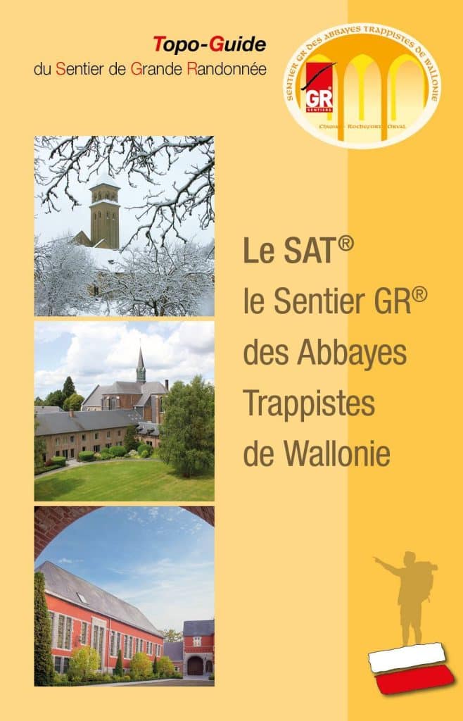
- The Trappist Abbeys Trail (S.A.T) – GR©
This trip links Rochefort to Orval, two of the 5 Trappist abbeys in Belgium, on a 116 kilometer route. It follows the circuit designed by GR© during 6 days in the heart of the Ardennes with luggage transport and quality accommodation.
Find all the information concerning the organization of this trip on our website: https: //europaventure.be/de-rochefort-a-orval-par-le-sentier-des-abbayes/
- The Semois Trail – GR©
This trip connects Arlon to Bouillon along the meanders of the Semois on a 140 km long route. It follows the circuit designed by GR© during 6 days in the heart of the Ardennes with luggage transport and quality accommodation.
Find all the information concerning the organization of this trip on our website: https: //europaventure.be/de-arlon-a-bouillon-par-le-sentier-gr16-de-la-semois/
Do not hesitate to contact us if you wish to make a trip on one of the GR© trails.
Find all our itineraries in the tab “Our destinations” on our website ( https://europaventure.be/randonnees-organisees/ )


